
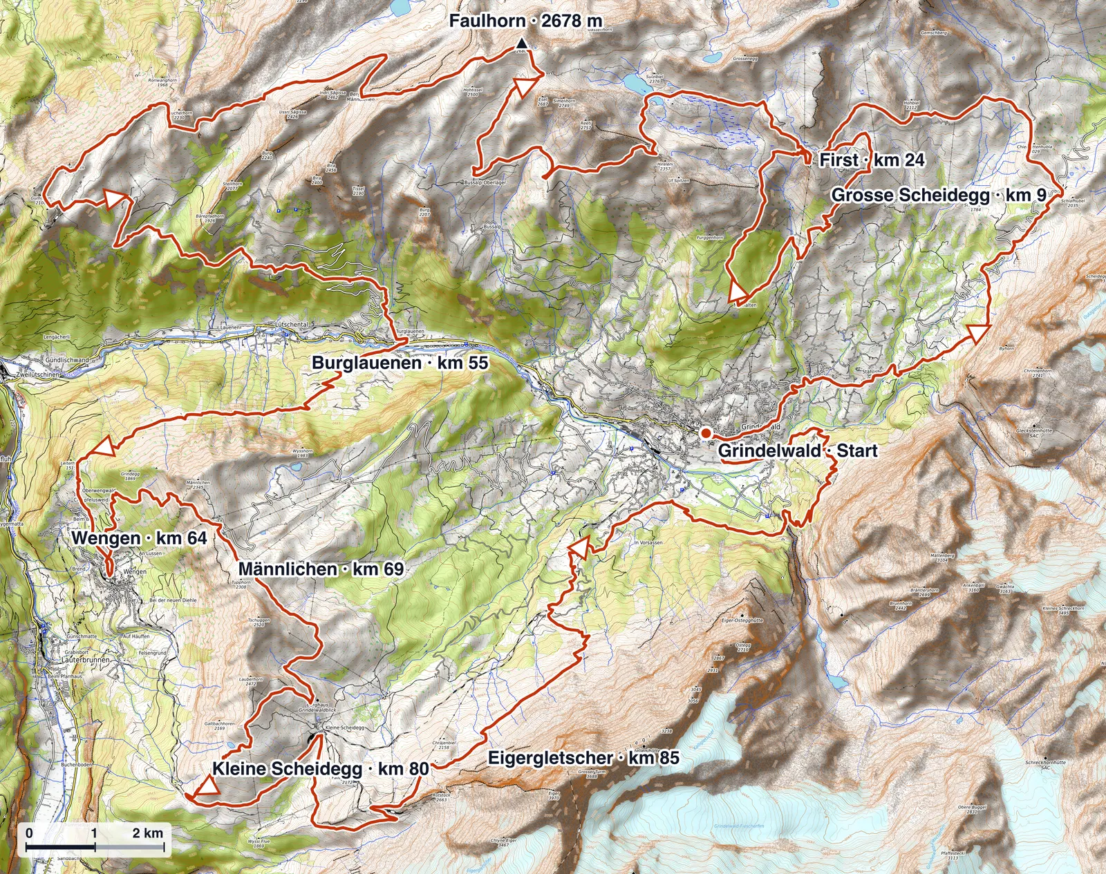
E101 starts and finishes in Grindelwald at around 1,034 m. The loop circles the Eiger massif through the classic Bernese Oberland. The highest point is approximately 2,678 m, the lowest around 891 m.
Course character
E101 is not an evenly runnable 100 km loop. Long climbs, technically demanding descents and several exposed passages above 2,000 m alternate with faster valley sections. The decisive load comes in the second half: after the low point at Burglauenen, the climbs towards Wengen and Männlichen arrive on already tired legs. The profile therefore rewards a controlled start more than aggressive pacing over the opening kilometres.
Four acts, not one even loop
It helps to read E101 as four distinct acts rather than a single 100 km run.
- Night start and the first 1,000 m. From Grindelwald the course climbs almost from the start line to Grosse Scheidegg. The bunched field and the 04:00 darkness make it easy to start too hard.
- The high route around First and Faulhorn. After the descent to Bort the course climbs back into open, exposed terrain around First, the high point near the Faulhorn (about 2,678 m) and the long traverse towards Schwand, usually already in full sun.
- The technical middle to Burglauenen and Wengen. A long descent to the low point near Burglauenen, then the climb out of the valley to Wengen. This is where heat and accumulated fatigue first bite.
- The alpine finish. The steep climb to Männlichen, the passage near Kleine Scheidegg below the Eiger north face, the long night descent to Brandegg and a final sting up to Pfingstegg before Grindelwald.
Key climbs and descents
Read from the official checkpoint profile, the decisive efforts are concentrated and steep rather than spread evenly:
- Grindelwald → Grosse Scheideggkm 0–9+990 m112 m/km
- Bort → Firstkm 18–24+630 m113 m/km
- Burglauenen → Wengenkm 55–64+770 m86 m/km
- Wengen → Männlichensteepestkm 64–69+945 m193 m/km
The hardest descent mirrors them: Kleine Scheidegg to Brandegg drops roughly 1,170 m against about +465 m of counter-climbs, a long night descent that punishes quads and feet far more than the distance suggests. The pattern is consistent: E101 hides its difficulty in steepness and in where the climbs fall, not in raw altitude.
Terrain and surface
E101 is not one uniform surface. Most of the route follows narrow Swiss mountain trails (white-red-white), often steep, stony and in places exposed. Faster gravel and service roads appear on some descents and approaches, there is short tarmac through the villages and at start and finish, and the closing kilometres under the Eiger north face mix steep grassy slopes, streams and mountain path. The useful summary is a technical mountain trail with stony, exposed sections threaded through premium Jungfrau-region infrastructure, rather than long classic scree.
GPX download
The GPX download is available on the E101 race page.