
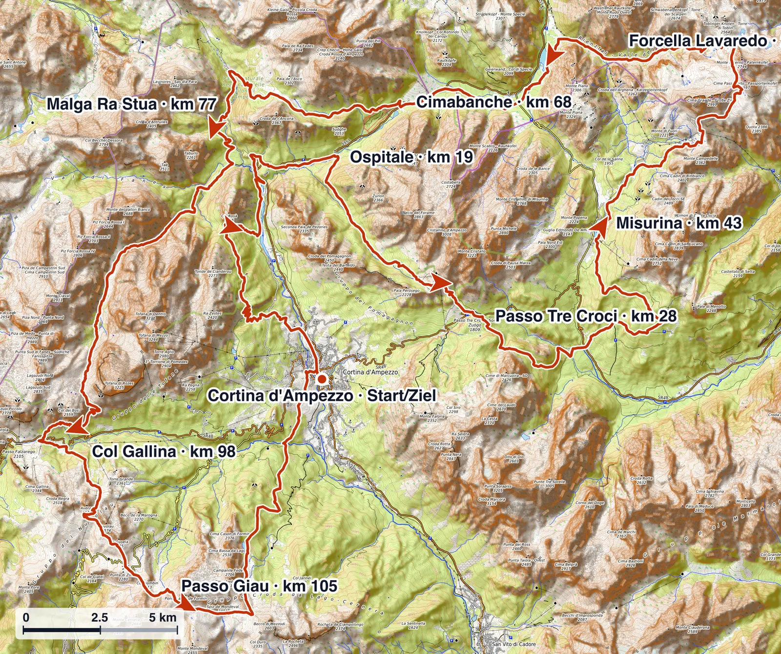
The Lavaredo 120K starts and finishes in Cortina d'Ampezzo at around 1,210 m. The loop circles the eastern Dolomites, with the high point at Forcella Lavaredo (about 2,456 m) reached at sunrise below the Tre Cime di Lavaredo.
Course character
The 120K is the queen race of the Lavaredo Ultra Trail: long climbs and technical descents on Dolomite terrain, broken by faster valley sections. The defining feature is the 23:00 night start, which puts the first half and the high point at the Tre Cime in darkness and dawn. The decisive load comes in the second half: after the Cimabanche life base at km 67, the climbing towards Col Gallina, Rifugio Averau and Passo Giau stacks up on tired legs. The profile rewards a controlled night more than aggressive pacing over the opening kilometres.
Four acts, not one even loop
It helps to read the 120K as four distinct acts rather than a single 120 km run.
- Night start in the valley. From Cortina the course works through the dark to Ospitale and the first hard cut-off at Passo Tre Croci. The fresh legs and the night make it easy to start too hard.
- The Tre Cime high point at first light. The climb past Misurina and Rifugio Auronzo to Forcella Lavaredo (about 2,456 m) reaches the high point of the course at sunrise, usually with cold and exposure, before the long descent to the Cimabanche life base.
- The decisive second half. From Cimabanche the climbing stacks back up on tired legs: Malga Ra Stua, the long pull through Malga Travenanzes to Col Gallina, then the steep wall to Rifugio Averau and on to Passo Giau.
- The final ridge to Cortina. From Passo Giau the course runs past Rifugio Croda da Lago and drops back down into Cortina for the finish in the Olympic Ice Stadium.
Key climbs and descents
Read from the official checkpoint profile, the decisive efforts are concentrated rather than spread evenly:
- Ospitale → Passo Tre Crocikm 18.7–28+657 m71 m/km
- Misurina → Forcella Lavaredokm 42.6–52.5+749 m76 m/km
- Cimabanche → Malga Ra Stuakm 67.5–77.1+533 m56 m/km
- Col Gallina → Rifugio Averausteepestkm 97.7–101.9+470 m112 m/km
The pattern is consistent: the 120K front-loads the high point at the Tre Cime and back-loads the steepest climbing. The short wall from Col Gallina to Rifugio Averau is the steepest pitch of the day and it falls past km 97, when legs and a possible second night are already working against you.
Terrain and surface
The 120K is Dolomite mountain terrain rather than a runnable forest ultra. The first half is deceptively friendly: wide gravel and old military roads, forest paths and longer flowing descents let you move well, with only the narrow switchbacks and the climb to the Tre Cime hinting at what is coming. The cost arrives in the second half, and it is muscular more than vertical.
The stony descent off the Tre Cime works feet and quads hard, the valley after Malga Ra Stua and Malga Travenanzes mixes loose limestone, roots and stream crossings, and the closing kilometres add rocky, rooted trail before a long descent from Rifugio Croda da Lago that ends legs more than it ends the clock. There is short tarmac through Misurina and at start and finish in Cortina. The useful summary is a technical Dolomite mountain trail whose difficulty is back-loaded into loose, rocky descents, rather than concentrated in one steep wall.

Navigation and markings
The course is marked with reflective way markers that catch a headlamp beam, so the night sections stay navigable as long as you keep markers in sight. The organiser uses no paint on the trails, and the regulation is explicit: if you can no longer see way markers, turn back. Navigation is rarely the problem in daylight with a full field, but it gets harder on the lonely, technical second half at night and in fog, where tired runners miss sudden turns. The first narrow singletrack after the fast start is also a known congestion point, so expect to queue early rather than force the pace.
GPX download
The GPX download is available on the Lavaredo 120K race page.