ENDURING MOTION
Wild 70 runners in the high Alps between Kandersteg and Crans-Montana
Race Hub · 2026

Wild 70 2026: Course & Race Strategy

This page brings the publicly available information for Wild 70 2026 into one place: course, cut-offs, mandatory kit, weather and the final two weeks of preparation.

Distance72 km
Elevation gain4,600 m D+
Start11 September 2026, 07:00
Time limit17 hours 30 minutes
Elevation profile

Course · 72 km · 4,600 m D+

A point-to-point course from Kandersteg (1,170 m) to Crans-Montana. Move the cursor or use the arrow keys across the profile to reveal distance, elevation and the next checkpoint.

steep climbclimbrollingdescent
drop bagwater onlycut-off

GPX analysis: 70.4 km and roughly 4,355 m D+. Organiser figures: 72 km and 4,600 m D+.

Three key segments from the course and GPX
  1. 01

    Kandersteg to Bunderschrinde

    km 0–11·+1,214 m climb·high point 2,378 m

    The first major climb starts immediately. This steep opening rewards restraint far more than matching the pace of your start wave.

  2. 02

    Lenk to Cabane Wildstrubel

    km 36–50·about +1,785 m climb·high point 2,788 m

    This is the decisive high-alpine block. From the low point in Lenk, the course launches into its longest and highest climb.

  3. 03

    Rawil to Crans-Montana

    km 50–72·more than 1,200 m descent·final 11 km after Tseuzier

    The route stays high and exposed beyond the hut before the long descent to Tseuzier and the rolling finish into Crans-Montana.

Topographic map of the Wild 70 point-to-point course from Kandersteg to Crans-Montana, with direction arrows, aid stations and the high point at Cabane Wildstrubel (2,788 m)
The Wild 70 course on the topographic map: the dots mark the start in Kandersteg and finish in Crans-Montana, white arrows show the direction of travel, labels mark the main aid stations with official kilometres, the triangle marks the high point of the course at Cabane Wildstrubel (about 2,788 m). Map data: © OpenStreetMap contributors, SRTM · map style: © OpenTopoMap (CC-BY-SA)

Based on public sources and the official GPX file. Last updated on 15 June 2026.

Wild 70 links Kandersteg with Crans-Montana. The official course is 72 km with 4,600 m D+; GPX analysis gives 70.4 km and roughly 4,355 m D+. The route is a Swiss alpine mix of steep passes, runnable panoramic trails, technical mountain paths and the exposed finish through Bisse du Ro.

View across an alpine valley with green slopes and a blue sky

Course character

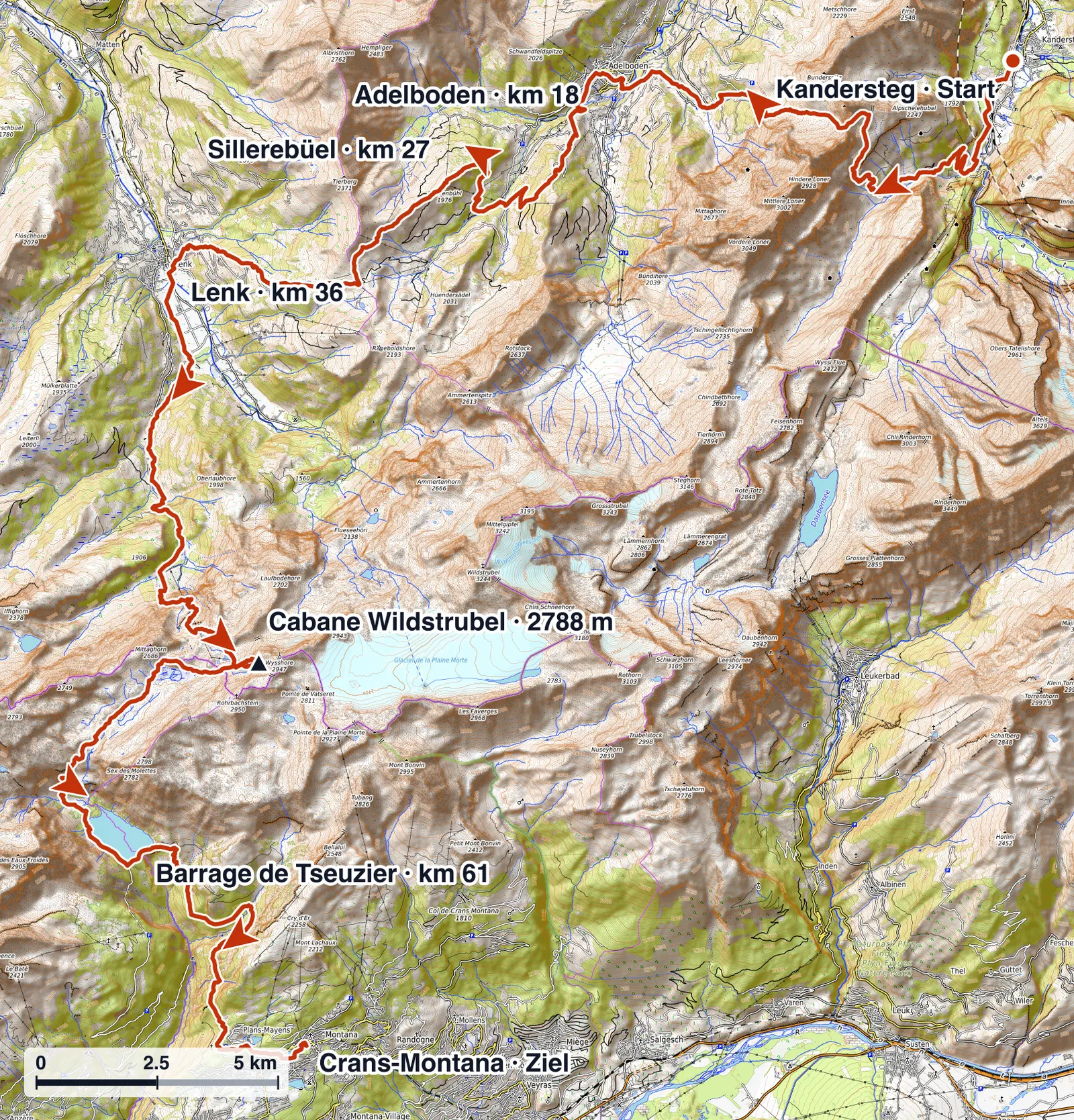
Wild 70 is not continuous rough skyrunning, but it is clearly alpine. The first climb to Bunderschrinde arrives almost without a warm-up, then Adelboden, Sillerebüel and Hahnenmoos bring more rhythm changes and more runnable sections. The race day is decided after Lenk: Iffigenalp, Cabane Wildstrubel, Rawil and the long way to Tseuzier combine altitude, exposure and fatigue.

Four acts, not one even line

It helps to read Wild 70 as four distinct acts rather than a simple 70 km connection.

  1. Kandersteg and the early alpine test. From the start the course climbs directly to Bunderschrinde. This is the first filter and not a good place to chase your start wave.
  2. Adelboden, Sillerebüel and Hahnenmoos. This middle part feels more runnably Swiss, but it keeps changing: wider tracks, slopes, pasture crossings and technical trail sections alternate.
  3. Lenk to Cabane Wildstrubel. The main high-alpine block climbs via Iffigenalp into the highest part of the race. Wind, fog, snowfields and slower movement are realistic planning factors here.
  4. Rawil, Tseuzier and Bisse du Ro. After the high point the course is not finished. The long descent, the reservoir and the exposed Bisse du Ro section demand focus when the legs are already heavy.
Runners on a pale scree path between rock walls

Key climbs and descents

Read from the official checkpoint data, the load is not spread evenly. The steepest block comes after Iffigenalp, exactly when more than 40 km are already in the legs:

  • Kandersteg → Bunderschrindekm 0–10.7
    +1214 m113 m/km
  • Adelboden → Sillerebüelkm 18.1–27.3
    +959 m104 m/km
  • Lenk → Iffigenalpkm 36–44.4
    +561 m67 m/km
  • Iffigenalp → Cabane Wildstrubelsteepestkm 44.4–50.1
    +1224 m215 m/km
Accent = the steepest climb of the day. Bars: elevation gain from the official checkpoint data.

The hardest mental descent starts after the Rawil sector. On paper the course loses a lot of height towards Tseuzier, but in practice descent, traverse and technical passages keep alternating. That is why the finish after Barrage de Tseuzier is not a cooldown, but one last concentration test.

Terrain and surface

The course mixes alpine mountain paths, meadows and pasture crossings, gravel, steep descents and exposed traverses. Bunderschrinde is the first clear alpine marker: a steep climb followed by a loose gravel descent that needs sure footing rather than speed. The Iffigenalp to Cabane Wildstrubel block is the second, with stony high terrain and exposed sections along the mountainside. Bisse du Ro adds a spectacular but focus-heavy finish, a path cut into the rock with a long suspension bridge of around 120 m, where tired legs and exposure meet.

Tactics

Wild 70 Cut-offs and Intermediate Times 2026

Three start waves from 07:00, four official intermediate limits and a 00:30 finish closure in Crans-Montana.

Wave 1 starts at 07:00, wave 2 at 07:10 and wave 3 at 07:20. Allocation is based on the general UTMB Index. Starting in an earlier wave incurs a two-hour penalty; starting later is allowed.

CheckpointkmD+D-2026 cut-off
Kandersteg0.00 m0 m07:20
Ueschine7.5561 m4 mNo official cut-off
Bunderschrinde10.71,214 m6 mNo official cut-off
Louwene13.71,214 m701 mNo official cut-off
Adelboden18.11,337 m1,177 m11:45
Chuenisbärgli21.71,801 m1,238 mNo official cut-off
Sillerebüel27.32,296 m1,491 mNo official cut-off
Hahnenmoos Pass30.62,404 m1,623 mNo official cut-off
Lenk36.02,406 m2,510 m16:00
Iffigenalp44.42,967 m2,553 m18:00
Cabane-Rawil junction49.53,950 m2,573 mNo official cut-off
Cabane Wildstrubel50.14,191 m2,573 mNo official cut-off
Col du Rawil52.74,246 m2,989 mNo official cut-off
Barrage de Tseuzier60.84,277 m3,670 m23:00
Crans-Montana72.04,600 m4,227 m00:30

Data: Wildstrubel by UTMB 2026. Official closing times apply when leaving the checkpoint.

Where time is lost at Wild 70

Adelboden closes at 11:45, Lenk at 16:00, Iffigenalp at 18:00 and Barrage de Tseuzier at 23:00. The total time limit is 17 hours 30 minutes. Linear planning is risky because the second half gets much slower: the long climb after Lenk, the altitude at Cabane Wildstrubel and the technical finish after Tseuzier cost more time than the distance suggests.

Pacing the 17.5-hour limit

The first major tactical marker is Adelboden. If you are already fighting the limit there, the hardest part of the race is still ahead. The strategy that holds up is calm to Bunderschrinde, controlled through Adelboden and Hahnenmoos, then deliberately conservative into the Wildstrubel block.

A realistic finish-time orientation

With 4,600 metres of climb under a 17-hour-30-minute limit, finish times spread widely. As a rough orientation, not a guarantee:

  • Elite7 h9 h
  • Strong amateur10 h12.5 h
  • Mid-pack13 h15 h
  • Back of field15 h16.5 h
  • Cut-off fight16.5 h17.5 h
Illuminated Crans-Montana sign at night beside the water

Self-support, support points and drop bag

Wild 70 runs on partial self-support. Between aid stations you must cover food, water and weather equipment yourself. Crew access is limited to Adelboden, Lenk and Barrage de Tseuzier. The organiser transports the runner bag to Crans-Montana, not to an intermediate station, so do not plan around a change bag in Adelboden or Lenk.

Aid stations

Aid stations at Wild 70

Aid points arranged along the course. At the three official crew-access points in Adelboden, Lenk and Barrage de Tseuzier, one support person per runner may enter the official aid zone.

05 / 15km 18.1

Crew access allowed

Adelboden

Cut-off11:45

Drinks

  • Water
  • Isotonic drink
  • Coca-Cola

Sports nutrition

  • Näak products
All checkpoints as a list
  1. Kanderstegkm 0.0Start supply

    Drinks: Water, Isotonic drink, Coca-Cola

    Sports nutrition: Näak products

  2. Ueschinekm 7.5Water only

    Drinks: Water

  3. Bunderschrindekm 10.7Basic supply

    Drinks: Water

  4. Louwenekm 13.7Water only

    Drinks: Water

  5. Adelbodenkm 18.1Crew access allowed

    Drinks: Water, Isotonic drink, Coca-Cola

    Sports nutrition: Näak products

  6. Chuenisbärglikm 21.7Basic supply

    Drinks: Water

  7. Sillerebüelkm 27.3Basic supply

    Drinks: Water, Isotonic drink, Coca-Cola

    Sports nutrition: Näak products

  8. Hahnenmoos Passkm 30.6Basic supply

    Drinks: Water

  9. Lenkkm 36.0Crew access allowed

    Drinks: Water, Isotonic drink, Coca-Cola

    Sports nutrition: Näak products

  10. Iffigenalpkm 44.4Crew access allowed

    Drinks: Water, Isotonic drink, Coca-Cola

    Sports nutrition: Näak products

  11. Cabane-Rawil junctionkm 49.5Basic supply

    Drinks: Water

  12. Cabane Wildstrubelkm 50.1Basic supply

    Drinks: Water, Isotonic drink, Coca-Cola

    Sports nutrition: Näak products

  13. Col du Rawilkm 52.7Basic supply

    Drinks: Water

  14. Barrage de Tseuzierkm 60.8Crew access allowed

    Drinks: Water, Isotonic drink, Coca-Cola

    Sports nutrition: Näak products

  15. Crans-Montanakm 72.0Finish supply

    Drinks: Water, Isotonic drink, Coca-Cola

    Sports nutrition: Näak products

Source: Wildstrubel by UTMB 2026. Listed supplies are water, isotonic drink, cola and Näak products; availability may change.

Gear check

Wild 70 Mandatory Kit 2026

The Wild 70 mandatory kit explained through alpine logic: what gets checked, what counts in the race and which items are regularly underestimated.

The organisation may activate a hot-weather or cold-weather kit in addition to the base kit. The current official race information remains authoritative.

Base kit

  • Running pack or suitable carrying system for the timing chip and mandatory equipment, worn throughout the race.
  • Smartphone with working international roaming in Switzerland, fully charged, switched on and never in flight mode. Save safety numbers, do not block your number, and install and activate LiveTrail. An external battery is strongly recommended.
  • Personal cup of at least 15 cl; bottles or flasks with lids are not accepted.
  • At least 1 litre of water and a food reserve, with 800 kcal recommended.
  • Two working headlamps with spare cells or batteries for each; at least 200 lumens recommended for the main lamp.
  • Survival blanket at least 1.40 × 2 m or survival bag, whistle and self-adhesive elastic bandage at least 100 × 6 cm.
  • Waterproof breathable hooded jacket with sealed seams; at least 10,000 mm hydrostatic head and RET 13 recommended.
  • Long trousers or a legging and sock combination that fully covers the legs.
  • Non-cotton warm long-sleeve top of at least 180 g, or a top of at least 110 g combined with a DWR-treated windproof jacket. The windproof does not replace the waterproof.
  • Passport or identity card.

Hot-weather kit

  • Sunglasses, desert cap or covering for head and neck, sunscreen with SPF 50 recommended, and at least 2 litres of water.

Cold-weather kit

  • Additional warm layer such as a down jacket, protective glasses, hat, warm waterproof gloves, waterproof overtrousers and robust fully closed trail shoes. Minimalist and ultralight shoes are excluded.

Also recommended

Bowl and utensils for meals, spare warm clothing, poles, anti-chafe cream, a CHF 20 note, GPS watch, knife or scissors for bandages and an emergency sewing kit.

Weather

Wild 70 Weather 2026: Conditions on the Course

Typical September conditions in the Bernese Oberland, organised by elevation zone and race phase.

September combines mild valleys with early-autumn conditions above 2,500 m: warm valley sections around Kandersteg and Lenk, cold and exposed passages at the Wildstrubel, and a long descent that slower runners only reach after sunset.

Bare rock walls and scree under a clear sky

Weather phases on the Wild 70 course

The point-to-point course runs from the valleys up to 2,788 m at Cabane Wildstrubel, where wind, fog or temperatures near freezing are possible. The useful question is therefore not a single forecast for Kandersteg, but how conditions change along the route, from the cool start through the exposed high section into the evening.

  1. 01

    km 0–18 · Kandersteg to Adelboden

    Cool start, rapid elevation gain

    The route climbs above 2,300 m early. Shade, wind and wet ground can make the morning considerably colder.

    Decision: Keep a warm layer and gloves accessible and control effort on the first climb.

  2. 02

    km 18–36 · Adelboden to Lenk

    Sun and pass conditions

    Open slopes and two passes alternate with the low valley point in Lenk.

    Decision: Use sun protection early, then reset water and weather layers in Lenk before the main climb.

  3. 03

    km 36–53 · Lenk to Col du Rawil

    Highest and most exposed section

    The course climbs to Cabane Wildstrubel at 2,788 m. September can bring wind, fog and a rapid temperature drop.

    Decision: Reassess conditions before Iffigenalp and keep waterproof, hat and gloves accessible.

  4. 04

    km 53–72 · Rawil to Crans-Montana

    Long descent into evening

    A long descent follows the high plateau; slower runners reach Tseuzier and the finish after sunset.

    Decision: Prepare lights early and leave Tseuzier with enough energy for the final rolling kilometres.

Hot kit, cold kit and the variant of the year

The mandatory equipment includes a separate hot-weather kit and cold-weather kit, and the organiser decides which one is required based on the forecast, telling every runner before bib pick-up. Part of your packing is therefore only finalised a day or two out. The cold kit adds a warm third layer (down-jacket type), protective glasses, a beanie, warm waterproof gloves and waterproof overtrousers; the hot kit adds sun protection and a minimum of 2 litres of water. In bad years the course itself can change: in 2024 the high passes were rerouted to keep runners lower after heavy snow and a sharp drop in temperature. Plan for both extremes rather than the average September.

Preparation

Wild 70 Checklist 2026

The last 14 days before the 11 September start, organised by taper, race week, final days and race day.

The final two weeks no longer build fitness. They remove open decisions: a complete base kit, the weather kit activated by the organiser and clear logistics for the point-to-point course from Kandersteg to Crans-Montana.

The four phases before the start

  1. 14–8days

    Lock the system

    • Complete the final longer session
    • Finalise shoes, pack and poles
    • Confirm travel to Kandersteg and return from Crans-Montana
  2. 7–4days

    Check mandatory equipment

    • Check base, hot-weather and cold-weather kits separately
    • Test LiveTrail, roaming and both lamps
    • Plan nutrition around Adelboden, Lenk and Tseuzier
  3. 3–1days

    Prepare the weather decision

    • Check any activated additional kit
    • Confirm start wave and final notices
    • Pack everything in order of access
  4. 07:00start

    Race morning

    • Arrive early at the ice rink
    • Keep phone and LiveTrail switched on
    • Keep cup, water and weather layer accessible

Point-to-point logistics

Wild 70 finishes in a different valley from the start, so travel needs planning. On the Friday morning the organiser runs a free bus-and-train transfer from Crans-Montana to the start in Kandersteg, booked in advance through your MyUTMB account. After the finish there is no organiser transport back to Kandersteg, so plan your return by public transport or carpool. Supporters can reach the start, the Lenk aid station and the finish in Crans-Montana by bus. Your 30-litre drop bag travels from Kandersteg to the finish only, with no bag at Adelboden or Lenk, and the organiser runs shuttles back to Crans-Montana if you withdraw or miss a cut-off.

Common questions

Questions about the Wild 70

When is Wild 70 2026?

Wild 70 starts on Friday 11 September 2026. Wave 1 leaves the Kandersteg ice rink at 07:00.

How long is Wild 70?

The organiser lists 72 km and 4,600 metres of climb, finishing in Crans-Montana.

What is the time limit?

The total time limit is 17 hours 30 minutes. The finish closes at 00:30 on Saturday.

Where is crew support allowed?

One support person per runner may enter the official aid zone in Adelboden, Lenk and Barrage de Tseuzier.

Are there intermediate cut-offs at Wild 70?

Yes. Beyond the overall limit of 17 hours 30 minutes, several intermediate cut-offs apply at the main checkpoints. Leaving a checkpoint after its official closing time means elimination. The exact closing times for each checkpoint are in the cut-off table on this page.

Which rain jacket meets the Wild 70 requirements?

The jacket needs at least 10,000 mm water column, sealed seams and an integrated or attached hood. Ultralight models under 100 g rarely meet these requirements. Reliable models for alpine ultra races typically weigh 150-250 g.

Why are two headlamps required?

Wild 70 starts in the early morning and for slower runners can extend into the night. Two separate working lamps are mandatory. A dead lamp with fresh batteries does not count as a second lamp. Both must work throughout the race.

Why a collapsible cup instead of a flask with a lid?

Aid stations at UTMB races pour drinks into open containers brought by runners. A collapsible cup without a lid is required to receive drinks at the station. Softflasks with drinking valves are not accepted for this purpose.

How hot does it get at Wild 70 in September?

In the valley near Kandersteg, temperatures of 25-35 °C are possible in September. On exposed ridges above 2,000 m it can be 4-10 °C. The transition happens within a few hours.

Can the Wild 70 course be changed because of weather?

Yes. The organiser can change or shorten the course at short notice, or stop the race, for example in case of thunderstorms, strong winds or other safety risks. Check Wildstrubel by UTMB communications the day before and again on race morning, keep your smartphone switched on, and do not plan exclusively around a previously saved route or cut-off table.

What must be done the day before Wild 70?

Pack complete and closed. Both headlamps tested. Phone fully charged with LiveRun installed. Emergency numbers saved. Collapsible cup checked. All mandatory kit present.

Newsletter

Science-backed notes on training, recovery, and racing smarter in the mountains

Join the newsletter and get thoughtful new writing when it's published. No noise, just useful notes for mountain runners.

More race hubs